Independence Valley, Elko County, Nevada
Overview
A rhyolite dome situated on the Independence Valley property, northeastern Nevada, remains untested and Peloton geophysical modelling of magnetic and CSAMT data has identified multiple structures within the dome complex that are recommended for drilling.
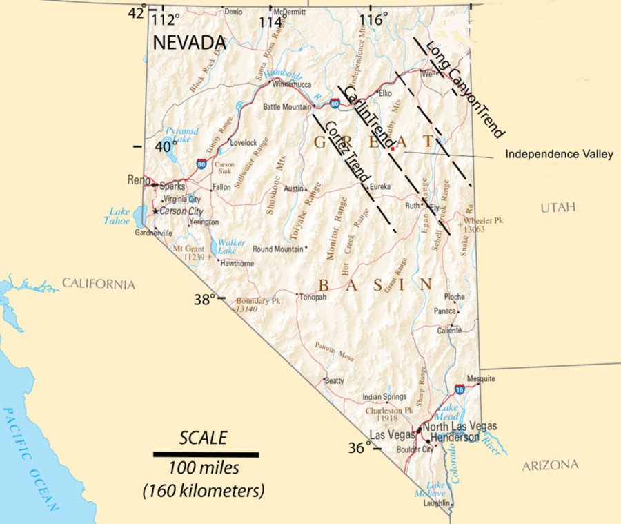
Independence Valley is situated on the Carlin Gold Trend, and is also within the historical Spruce Mountain mining district which hosted many historic base and precious metals mines since the 1840’s. The Spruce Mountain deposits have typically been associated with rhyolitic and granitic intrusive rocks which Peloton believes are the “Smoking Gun” – indicating the location of the structural feeders for both the granitic magmas and gold-silver bearing mineralized fluids.
The Independence Valley rhyolite dome and hypabyssal feeder dike is the largest untested rhyolite and hosting structure in the Spruce Mining District.
Description, Location & Access
Independence Valley consists of 21 mineral claims covering about 422 acres and is located about 39 miles (63 kilometers) southeast of Wells, Nevada. The property is 100% owned by Peloton and there are no royalties outstanding. Access is via Highway 93 south from Wells, then the Tobar and Spruce Mountain Roads.
Geology
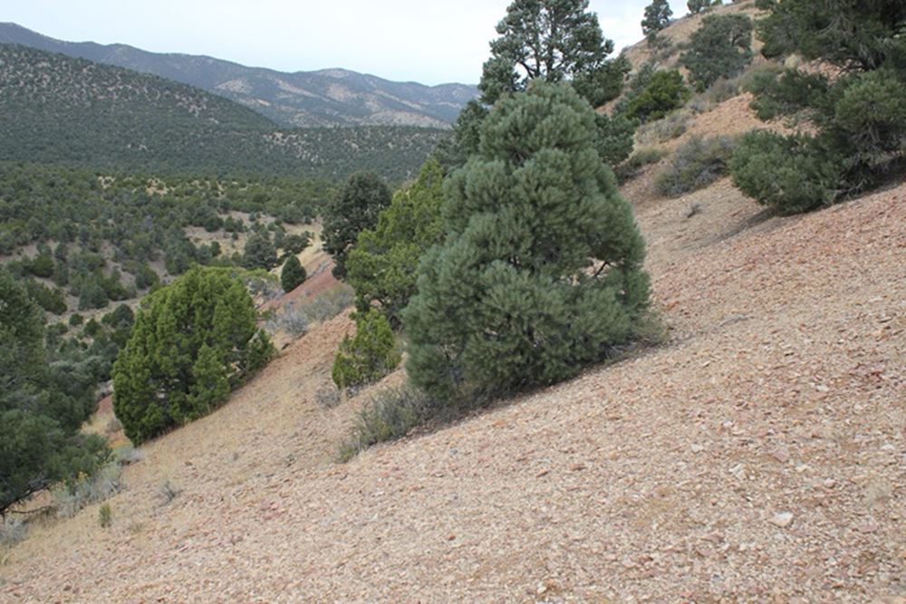
The stratigraphy of the Independence Valley property consists of at least several hundred meters of exposed Paleozoic sedimentary rocks that include, in stratigraphic order (oldest to youngest) Ely Limestone, Riepe Spring Limestone, and Pequop and Rib Hill Formation limestones. The base of the sedimentary section is not exposed in the property area and overall stratigraphic thickness is uncertain. In the north-central part of the claim block, the Paleozoic sediments are overlain and intruded by a locally mineralized rhyolite flow-dome complex that includes rhyolite flow, hypabyssal intrusive, and associated phreatic surge tuffs. The hypabyssal intrusive contains rafted blocks of silicified and mineralized Paleozoic carbonate rocks which indicate mineralization in the subsurface.
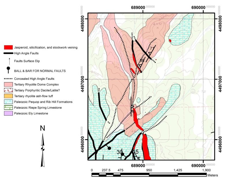
A broad northerly striking anticline formed in the Paleozoic sedimentary rocks is central to the Independence Valley claims at depth. Tertiary northeast-, northwest- and lesser east-west-striking high-angle normal faults cut and displace this anticline. Two of the most continuous northeast-striking normal faults form a northeast-striking graben within the central claim area. A mineralized rhyolite intrusive/extrusive dome complex intrudes both northeast- and northwest-striking mineralized normal faults in the northern Independence Valley property. Magnetic anomalies identified by the USGS and confirmed by Peloton are coincident with the rhyolite dome complex and the southeastern margin of an inferred shallow granitic pluton is coincident with both dome and magnetic anomalies (Raines, 1996). Rhyolite flows and tuffs unconformably overlie the Paleozoic rocks and conceal earlier normal faulting and mineralization. Several younger northwest-striking normal faults of small displacement cut the rhyolite.
Exploration Work Completed
Peloton has completed geologic mapping, soil geochemistry, and geophysical surveys including magnetics, gravity and CSAMT.
One reverse circulation angle hole (-50-degree, 235 Azimuth) was drilled on the property in 2019 to a length 1,140 feet and depth of about 873 feet. The hole was drilled away from the rhyolite dome structure and targeted a potential down dropped east limb of an NNW trending antiform. This hole encountered detectable gold mineralization in 125 of the 5-foot sampling intervals (625 total feet) and including 235 feet of continuous gold, in a tuffaceous volcanic rock, fine grained hypabyssal intrusive and in the contact zone with adjacent Paleozoic carbonate sedimentary rocks. In addition, this hole intersected visible argillic hydrothermal alteration over a continuous core length of about 500 feet.
Geophysical Modelling
Modelling of the geophysical data, including magnetics, gravity and CSAMT, identified multiple structures within the rhyolite dome complex that are recommended for drill testing. Alteration zones are shown in blue.
Highlights
- Drill Ready Gold Target
- On the Carlin Trend and in the Spruce Mountain Mining District (SMMD)
- Rhyolitic intrusives are the “Smoking Gun” at SMMD
- The largest untested rhyolite dome in the SMDD
- Mapping, geochemistry and geophysics completed
- Only one hole has been drilled returning 625 total feet of detectible gold mineralization, including 235 feet of continuous gold mineralization, and 500 feet of continuous argillic hydrothermal alteration
- Multiple zones within identified within the rhyolite dome are recommended for drilling
Richard C. Capps, PhD, is the qualified person under National Instrument 43-101 that has approved the technical information contained within this website. Mr. Capps is the Company’s Senior Geologist and a Director.