Texas Canyon, Elko County, Nevada
Location, Status and Access
The Texas Canyon Uranium Property (“Texas Canyon” or the “Property”) consists of 44 claims (909 acres) as part of the western portion of the North Elko Lithium Project (NELP) contiguous claim block that now totals 442 claims (9,130 acres). Texas Canyon and NELP are located in the northeastern part of Elko County, about 70 kilometers northeast of Wells, Nevada, and are 100% owned with no royalties outstanding. Access is from Wells via Highway 93 and the Thousand Springs and Rock Springs Roads.
Property History & Recent Activity
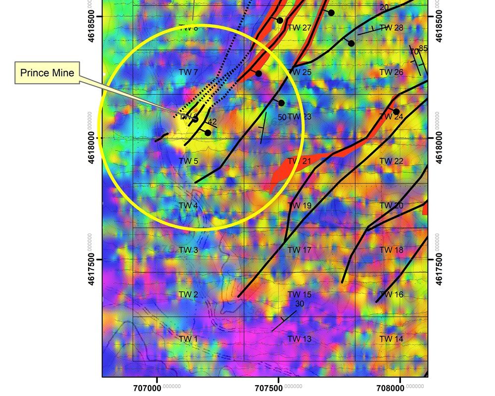
Texas Canyon hosted the historic Prince Mine which extracted high grade Uranium (U3O8) in the 1950’s from a 300 foot adit into a uraniferous breccia pipe on the Property. Historical records (Redfern 1977) state average mine grades of 1% Uranium with samples running as high as 7% Uranium. Peloton sampling has returned up to 1% Uranium.
In 2023, Surge Battery Metals Inc. (Surge) made a major lithium in clay discovery on claims that are immediately adjacent to and tied onto Texas Canyon to the west. Surge will be conducting its fourth drill campaign in the summer of 2025, and is working toward a Preliminary Economic Assessment. Surge has reported an indicated lithium resource of 11.24 million tonnes of Lithium Carbonate Equivalent (LCE) grading an average of 3,010 ppm Lithium. Surge has stated that this is the highest-grade lithium in clay resource in North America.
Geology and Mineralization
Texas Canyon is centered on a broad zone of structurally controlled hydrothermal alteration, including decalcification and silica replacement of the limestone, localized along numerous northeast-striking high-angle veins and in bodies of clast-supported polyphase hydrothermal breccia and adjacent hydrothermal replacement zones. Silicification is common to the mineralization and occurs within strongly altered limestone and breccia that is younger than the high angle structures that it cuts.
Geologic mapping, rock-chip sampling, and a detailed surface radiometric survey shows that mineralization is related to subvertical bodies of hydrothermal breccia and alteration along synvolcanic graben/caldera related structures similar to known uranium-bearing diatremes in other areas.

Historic workings occur within the mineralized areas and the largest of these workings is the Prince Mine. The Prince Mine was reportedly developed by prospectors in 1953 in order to determine the uranium potential of anomalous uranium surface occurrences they discovered. A subsequent Master’s thesis on the occurrence reported a 45° decline into the mineralization for a length of 300 feet and vertical depth of about 200 feet. A detailed radiometric survey identified a greater than 400 foot diameter roughly circular anomaly grading over 1% equivalent uranium at the same location. Surface samples taken within the anomaly show values of over 1 % uranium. Two historic channel samples from the decline assayed 0.354 and 0.094 % uranium and average over 0.2 % U3O8. Individual grab samples in the decline assayed over 7 % uranium.
The nearly circular outline of the anomaly suggests that the breccia body is nearly vertical and may be a breccia pipe (diatreme) hosted by the thick Pequop Formation limestone. The anomaly is centered on a greater than 2,500 foot long northeast structural zone and at least three other smaller but similarly mineralized anomalies occur along the length of the structure.

Work Done & Upcoming
Peloton has completed geologic mapping, rock-chip sampling, a detailed surface radiometric survey, and a regional airborne hyperspectral survey over the 44 original Texas Canyon claims. The Company has also completed a soil geochemistry sampling program over NELP which included Texas Canyon.
A regional airborne geophysical survey, including Texas Canyon, will be conducted in 2025 comprised of Magnetics, Radiometrics and VLF. Drilling on NELP for lithium, south-east of the Texas Canyon portion, is also planned for 2025.
Geologic Society of Nevada Property Abstract
The project is summarized in this abstract prepared for the Geologic Society of Nevada (GSN) Virtual Symposium 2020: Texas Canyon Project, Northeastern Elko County, Nevada, Richard C. Capps, Paula J. Noble, and Clark Jorgensen
Richard C. Capps, PhD, is the qualified person under National Instrument 43-101 that has approved the technical information contained within this website. Mr. Capps is the Company’s Senior Geologist and a Director.